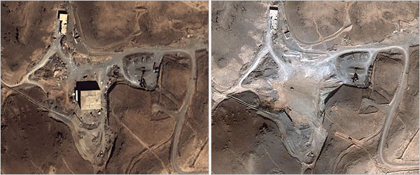
That site that Israel bombed, was apparently correctly identified in the news reports that we all saw last evening. This is a before and after shot:
As to the official reaction of Syria, Bruce McQuain makes an excellent point:
Seems to me if it was an empty building the Israelis took out, the Syrians would milk it for every bit of propaganda value possible (hopefully more skillfully that Saddam’s “Baby Milk Factory”). Instead we have what looks like a scrubbed site.
Yes… And instead of the outraged screaming that you would hear if we had bombed an aspirin factory, let’s say , we have dead silence from Syrian authorities. It’s the best signal I can think of that our intelligence was right on the money.
I did get a chance to look at that site last evening, on Google Earth… and one thing that the pictures here do not show is the lay of the land. (They also don’t have nearly the resolution that the EARTH version has, for some reason)
The building that you see in one picture and don’t see in the other, is in a bit of a valley. That valley, gravity drains into the river. It’s also apparently deep enough, to make it a serious problem for anyone trying to do an air strike unless you’re coming at it from the west. The topo of the neighborhood suggests a drop off of about 150ft. below average terrain. This would be consistent, to my mind with a nuclear installation, not as I say an aspirin factory. I’m not sure how tall the building was, but it seems reasonable to assume that the site was picked and possibly re-landscaped slightly… so as to hide the roof below the average terrain.
Now the question becomes one of the other two reported sites, of the same North Korean design, also in Syria?
BBCT: Memeorandum which has more links up
Tags: BitsBlog, BO, hope, Israel, Men, Middle East Affairs, Money, NY, Picture, Syria, UN, W

